


Natural Attractions
Flat Lick Falls


A Jackson County Treasure!


A Jackson County Treasure!
Directions: Take US 421 to Gray Hawk. At the US 421 and Hwy 1071 Junction, turn west on Hays Road for 100 feet, then turn left on Lower Hays for 1mile, then turn right (just before the low water bridge), and go ½ mile, then turn left into Flat Lick Falls Recreational and Scenic Area.
Flat Lick Falls Scenic and Recreation Area is tucked into the hills of southern Jackson County and consists of recreational facilities, including primitive camping (check with us about RV camping), picnic shelter and restrooms, 86.09 acres of wooded land, cliffs and Flat Lick creek running through the middle of the property with a 28-foot water fall emptying into a large pool at the bottom of the falls. The creek flows into the Laurel Fork Creek. The falls can be viewed up close via the meandering paths along the cliff line including a paved path leading to a wheelchair accessible viewing platform.
There are paths leading to the bottom of the falls where a good splash in the creek feels great on a hot day! The area has been developed for recreational use including about 5 miles of trails for hiking, photography, repelling and primitive camping.
Flat Lick Falls is surrounded by lush greenery and rocky wooded forest. The naturally beautiful surroundings offer a clean picnic area with a gorgeous view of the falls surrounded by a kaleidoscope array of colored rocks and trees. Family hikes and camping can become a magical adventure, creating memories and traditions that will last a lifetime.
HIKING: There are about 5 miles of easy to medium hiking trails developed with some creek crossing to access the trails. One trail has easy access to a lookout platform that is wheelchair accessible. This paved trail is about 400 yards in length and situated so the falls can easily be viewed and photographed. For those who want a short hike to the base of the falls a short ½ mile hike with a bridge crossing the creek can be enjoyed by the whole family.
CAMPING: There are 5 tent sites with level gravel pads and grills along the creek. There are 8 RV campsites currently under constructionin in 2019. They will include electric/water hookups. Primitive camping is allowed throughout the park. There are restrooms, showers and running water in the cabin.
PICNICING: A picnic shelter and scattered picnic tables are available. The shelter and tables can be reserved for reunions and events. Call 606-287-8562.
SWIMMING: Swimming in the creek is allowed, but jumping off the falls is not as it is very dangerous and could be fatal.


McCammon Branch Falls - Gray Hawk, Kentucky
A Treasure in the Wilderness
McCammon Branch Falls is perhaps one of Jackson County's best kept secrets. A marvel of natural beauty, McCammon Branch Falls is located on McCammon Branch, just behind Gray Hawk Community Park. A mildly challenging rough and narrow trail leads from the field adjacent to the picnic shelter to one of the most spectaclar and seldom documented natural sites in all of Kentucky. A privately owned house is situated next to the trail in front of the falls, so please be respectful.
Alcorn Branch Falls - Arvel, Kentucky
A Sheltowee Trace Original
This Sheltowee Trace walk starts in a little-visited segment of the Daniel Boone National Forest. It leaves the community of Arvel, near the old Arvel post office, and takes an old dirt road before coming to a foot trail. From here, it descends from dry oak woodland into a moist valley where the Trace looks out on Alcorn Branch Falls, a low-flow drop that few folks ever see. This is a short walk suitable for most everyone. Todd Grocery, a true old-time country store at the trailhead, is worth a visit if it is open. Outstanding Features: Waterfall, solitude, and rock overhang
Resurgence Cave - McKee, Kentucky
Undeniably Beautiful
This Sheltowee Trace hike leads through the War Fork Gorge to Resurgence Cave, where War Fork emerges, flowing cool and clear year-round. War Fork flows through a geologically interesting valley. Much of this stretch is drained by caves underlying the War Fork Valley. War Fork holds water at Turkey Foot Campground, the hike starting point, but is often dry upstream. It again goes underground below Turkey Foot before resuming flow at Resurgence Cave. Outstanding Features: Cave with emerging stream, War Fork Gorge, and old homesite
Beulah Lake - Tyner, Kentucky
Out on the Water
Kentucky Scenic Byway
Off the Beaten Path
KY 89 in Rockcastle and Jackson Counties was designated a Kentucky Scenic Byway in 1996 by the Kentucky Department of Transportation. This 32-mile section of road spans two of the commonwealth's major watersheds, the Kentucky and the Cumberland, and has special sights to offer during the early seasons of the year. The wildflowers are especially abundant and spectacular, and the streams that parallel the road take on magnificent hues of azure.
If you are looking for a detour from busy I-75 through the Daniel Boone National Forest, travel on Scenic Byway 89. Travelers from the south should get off I-75 at Mt. Vernon exit 59). Follow signs to Livingston, cross the bridge and turn right. This road will run into Scenic Byway 89 to Irvine and follow State Route 52 to Richmond. From the north, exit I-75 at Richmond (exit 87} and reverse directions. You will enjoy scenic views and rock outcrops along the ridge tops, and lush vegetation along Indian Creek and the Rockcastle River.
This picturesque drive is great for exploration by bicyclists with experience on narrow, winding roads.
Please contact the Judge Executives office:
(606) 287-8562 fax (606) 287-1790
Daniel Boone National Forest
Appalachian Wilderness
Formerly known as the Cumberland National Forest, established in 1937, it was renamed in 1966 for Daniel Boone, who explored the Kentucky wilderness and returned with other pioneers to establish a settlement at Fort Boonesborough (then Virginia, now Kentucky). The forest was established in 1937 under the Weeks Act, which permitted the federal government to buy back lands in the east to form national forests. The principal large ownership which formed the basis of the Forest were the Stearns Coal and Lumber Company tract of 48,000 acres, the Castle-Craig Coal Company tract of 27,000 acres, and the War Fork Land Company tract of 22,000 acres. These were lands which had already been clear cut for lumber. The purpose was to manage the land to supply lumber into the future and to provide recreational opportunities.
The Daniel Boone National Forest contains some of the most beautiful scenery and topography anywhere in the world, with over 56,000 acres lying within the boundaries of Jackson County. Towering sandstone cliffs, waterfalls, natural arches and bridges characterize the land described by Daniel Boone as "Eden...a great forest on which stood myriads of trees, some gay with blooms, others rich with fruit." The forest offers a variety of opportunities for outdoor recreation. Activities include camping, picnicking, hiking, biking, hunting, fishing, swimming, and nature study. Spread across 21 counties of southern and eastern Kentucky, more than 708,000 acres of national forest system lands are managed within a 2.1 million-acre proclamation boundary. The forest is divided into four ranger districts: Cumberland, London, Redbird and Stearns.


One of Jackson County's best kept secrets!


Private property. Please be respectful.
One of Jackson County's best kept secrets!

Photo by Ulrich Burkhalter
Photo by Ulrich Burkhalter


Photo by Robert Culbertson

Photo by Robert Culbertson
Photo by Robert Culbertson


Just off HWY 421, facing south. View of Jackson County Court House in McKee.

Just off HWY 421, facing north.

Scenic Byway 89 is part of the bike route for the popular Redbud Ride, a hundred mile bicycle tour sponsored by London, KY annually, the middle of April.
Just off HWY 421, facing south. View of Jackson County Court House in McKee.
The 89 Scenic Byway begins and the Rockcastle side of the KY 490 bridge. Traveling northward, three miles of the byway is in Rockcastle County and the 29 mile Jackson County segment begins at the historic wooden bridge over Horse Lick Creek, continues through McKee and on the Estill County line at Drip Rock. At that point, one may continue on to Irvine in Estill County or turn left on the Hisel Road and travel to US 421 at Sand Gap or Morrill.

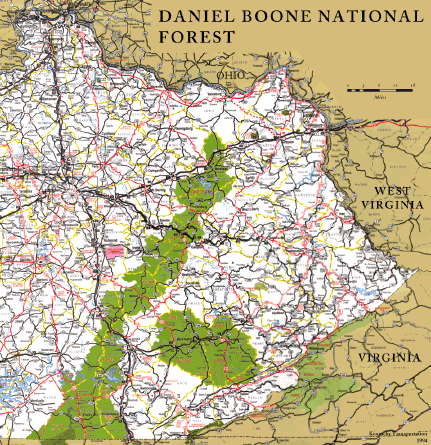
The Daniel Boone National Forest contains both public and private land in 21 eastern Kentucky counties extending from Rowan county in the north to McCreary county in the south. It is managed by the US Department of Agriculture's Forest Service. Several state parks, the Red River Gorge, and the Big South Fork National River and Recreation Area are located within the Forest.

The forest offers a variety of opportunities for outdoor recreation. Activities include camping, picnicking, hiking, hunting, fishing, boating, swimming, and nature study. In Jackson County, you will find all of these activities, only boating will be limited to canoeing some of the loveliest streams anywhere.
Two national forest campgrounds and recreational areas in Jackson County are S-Tree and Turkey Foot. Both are located just off Scenic Byway 89. The Sheltowee Trace National Recreation Trail runs through both campgrounds.
S-Tree Campground sits atop a ridge and provides 10 trailer/tent campsites and a satellite campground.
Turkey Foot Campground is situated along the banks of War Fork Creek and has 15 campsites. Both campgrounds have hiking and horseback riding trails, as well as picnic areas.
For information contact:
Daniel Boone National Forest
1700 Bypass Road
Winchester, KY 40391
(859) 745-3100
London Ranger Station
761 S. Laurel Road
London, KY 40744
606-864-4163


Mill Creek Wildlife Management Area
Two miles south of McKee, Kentucky. Primarily hilly with steep slopes and long, narrow ridge tops, with flats only in bottoms and on tops of ridges. Mostly forested with approximately 30 acres of openings. No developed facilities. Mobility impaired access to permit holders in designated area. The mobility impaired access area consists of the U. S. Forest Service trails that are open to ATVs which includes the Sheltowee Trace Trail and Renfro Loop Trail on the Southwest end of the WMA. For camping check with U.S. Forest Service. Check in for deer quota hunt is located at 24 Ranger Station Road, on US Forest Service property, north of Mill Creek WMA, off US 421, about a mile and a half east of McKee.
Public Hunting Area users must abide by the Kentucky hunting, trapping, and fishing regulations. It is incumbent on persons using Public Hunting Areas to become familiar with these regulations. Kentucky Department of Fish & Wildlife Resources provides these regulations on our website at fw.ky.gov or by calling
1-800-858-1549.
Location & Size: Jackson County, 13,009 acres
Elevation minimum 940 feet, maximum 1495 feet.
Area Habitat mostly forest: open land 5%, forest 95%, wetland 0%, open water 0%.
Entrance GPS coordinates: Latitude N 37.42396, Longitude W -84.06375


Convergence of Mill Creek Wildlife Management Area and the Horse Lick section of the Sheltowee Trace.


Convergence of Mill Creek Wildlife Management Area and the Horse Lick section of the Sheltowee Trace.